Trail Walking Gemeinde Absam - Halleranger – Innsbruck / Jour 8 - Photo

Halleranger – Innsbruck / Jour 8

 Greg813
Greg813

User

© OpenStreetMap contributors
Length
Length
13.9 km
Max alt
Max alt
2080 m
Uphill gradient
Uphill gradient
362 m
Km-Effort
Km-Effort  
23 km
Min alt
Min alt
582 m
Downhill gradient
Downhill gradient
1553 m
Boucle
Boucle
No
Creation date :
2022-08-05 06:50:15.622
Updated on :
2022-09-19 15:51:40.565

(0 Reviews)

Walking
Walking
3h56
Difficulty : Medium

Scan this QR Code to open this trail in the SityTrail application

FREE GPS app for hiking

Logo SityTrail SityTrail

IGN / Geographical institutes

Download SityTrail from the App Store Download SityTrail from Google Play

Logo SityTrail SityTrail World

The world is yours!

Download SityTrail from the App Store Download SityTrail from Google Play Download SityTrail on Huawei AppGallery

About

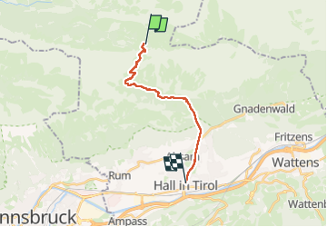
Trail Walking of 13.9 km to be discovered at Tyrol, Bezirk Innsbruck-Land, Gemeinde Absam. This trail is proposed by Greg813.

Description

Trek de 8 jours dans le Tyrol autrichien avec Mettons le Monde en Marche. Parcours de la voie de l'Aigle de Langkampfen à Innsbrück avec nuits en refuge.

Etape 8 : Halleranger – Innsbruck

Pour d'autres photos, voir le site de l'association :
https://mmm-rando.org/trek-la-voix-de-laigle-autriche-2022/

Elevation profile

Photos

Points of interest

Point of interest Gemeinde Absam - Halleranger Alm - Photo
Greg813
GEMEINDE ABSAM 
Point of interest Gemeinde Absam - Statue - Photo
Greg813
GEMEINDE ABSAM 

Positioning

Country:
Austria
Region :
Tyrol
Department/Province :
Bezirk Innsbruck-Land
Municipality :
Gemeinde Absam
Location:
Unknown
Start:(UTM)
687075 ; 5247541 (32T) N.

Trails nearby

Trail On foot Gemeinde Thaur - Adlerweg [005] - Photo
On foot
PRO

On foot

Very difficult
Gemeinde Thaur, Tyrol, Bezirk Innsbruck-Land, Austria
49 km | 93 km-effort
21h 9min
No


Close
My subscriptions